Stuchd an Lochain towers above Lochan nan Cat.
Meaning - Steep Conical Hill of the Lochain
Summit Location - NN48306, 44834
Height - 960m
Munro Number - 196
Distance - 8.24km
Total Ascent - 741m
Estimated Time - 2hrs up / 1hr down
Difficulty - 2/5
OS Explorer Map - OL48
Climbed - 2017
Weather - Overcast but summits mostly clear. Infrequent rain showers with a little
wind.
Stuchd an Lochain is in a fairly remote location. You’ll spend around an hour driving
on narrow, winding, single track roads to get to the base at Giorra Dam. This can
be tricky to find, don’t rely on your sat nav - take a good road map and check it
carefully. A couple of kilometres before you reach the dam the road is gated to keep
deer in (or out). Access isn’t a problem though - it’s unlocked.
Giorra Dam is also the start point for the walk to Meall Buidhe, another Munro a
few kilometres to the north. Since both the walks are reasonably short and the drive
in long some people will want to climb both in the same day, though you’d need to
return to the dam between the two peaks. My advice is to do them as two separate
walks, especially if you’re not visiting in the long summer months. The terrain to
get to each peak is somewhat tough - you’d need firm resolve to be able to march
past your car and up the next peak at the halfway point!
If you do choose to climb them both the same day start with Stuchd an Lochain as
the first part of the climb is rather steep and on a wet and muddy path - nice to
get this out of the way early. Once you reach a ridge at around the 700m contour
the going gets markedly easier, but there’s still a climb to a minor top and then
a 1.5km along an easy ridge that encircles Lochan nan Cat.
I climbed this on a fairly miserable afternoon, having climbed most of the neighbouring
peaks in the few days prior. The weather just about allowed me to see most of these.
Route
1 - Park close to the bridge under the dam, which cannot be crossed in a vehicle
as there is a locked gate. Instead cross this bridge on foot (you’ll need to climb
over the gate) and continue up on the track through the woods to reach the end of
the dam.
2 - The track continues by the loch towards a boathouse. After a few metres you’ll
see a small cairn and a faint path heading uphill. Follow this, which climbs a little
but also contours to the west to a point above the boathouse. You’ll cross several
small streams.
3 - After a while the path starts to climb quite steeply (and seems to become several
paths). Water flowing along the course of these paths a the steep gradient combines
to make the going fairly tough and slippery. At around the 700m contour you’ll gain
a ridge with a line of fence posts on top. Follow this to the west, still climbing
but much more easily on a more obvious footpath.
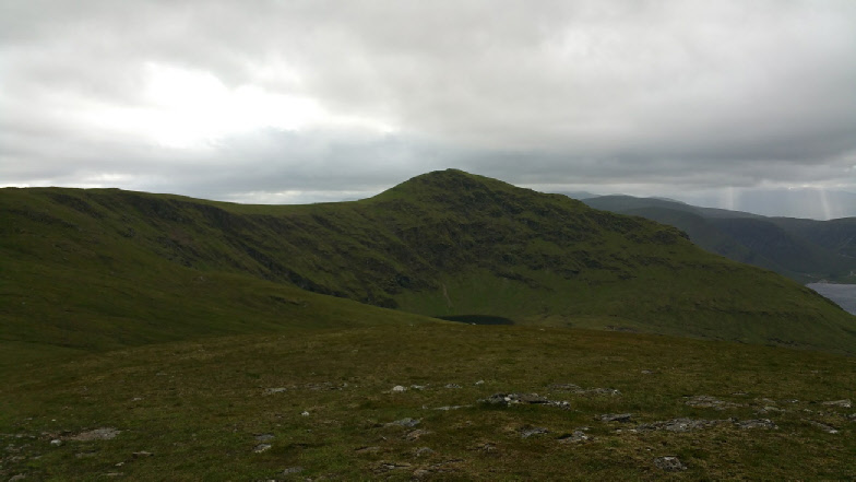
4 - You’ll reach a minor top and at this point you might get your first glimpse of
Stuc an Lochain across the corrie. The footpath continues to follow the fence posts
along an easy ridge, first in a southerly direction and then veering westerly. The
peak is around 1.5km away, reached after a short, steep, final climb.
5 - Return by route of ascent.