© Copyright Dominic Rhodes 2014-
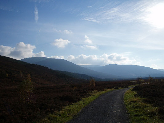
Mullach Clach a’ Bhlair, in the centre of the shot in the background.
Meaning -
Summit Location -
Height -
Munro Number -
Distance -
Total Ascent -
Time -
Difficulty -
OS Explorer Map -
Climbed -
Weather -
The start point for this Munro used to be Tolvah, on the west bank of the River Feshie. However the popular access bridge at Carnachuin was swept away in 2009. Access is now from the car park north of Achlean on the east bank, a greatly improved path leads south from there, crossing a number of burns. This is the route described in the instructions below.
Now that access is from Achlean, Mullach Clach a’ Bhlair could be more easily combined with an ascent of Sgor Gaoith. The two are linked by a high plateau.
After spending the morning shopping in Inverness I drove down to Achlean in Glen Feshie. The last time I was here was in January at the end of a three day epic (see trip report for Monadh Mor for the full details.) I was supposed to have ended that walk on this Munro but it wasn't to be. So I was back for another go!
In contrast to the last time I was here the skies were very clear and it was reasonably warm, certainly no snow that had been so instrumental in my failure last time. On it's own, Mullach Clach a' Bhlair looked as if would be a fairly simple walk as a good track led pretty much all the way to the summit. If it wasn't such a long walk up Glen Feshie it would be a very simple Munro to climb, the extra distance really just makes it a bit more of a slog.
After walking to the farm and the bridge just beyond it I opted to cross the river
to continue along the estate track, rather than the smaller footpath that runs through
the forest. After a long fairly dull walk along the tarmac I finally reached the
next bridge. This bridge is in a very bad way and care is needed crossing. One person
at a time! If the river looks to be in spate I wouldn't cross it -
After crossing a fairly big Land Rover track leads up the hill. As you reach the plateau another track runs left and right, following it to the right leads pretty much all the way up the summit where it was time to have some lunch. I briefly flirted with the idea of continuing on the track north along the plateau and then descending via the path past Carn Ban Mor. This would avoid much of the long boring walk along the estate track. However a very cold wind had started to blow and I decided to return the way I had come rather than face a long walk into the wind on the plateau.
As I approached the car it dawned on me this would probably be my last time in Scotland for a while, as I was to move abroad with work very shortly. Over the last year and a half I'd been to Scotland fairly regularly, I was definitely going to miss the place. My plans for the evening, to go and feast on the excellent Highland buffet in the Cairngorm hotel and enjoy a sample or two of the local Cairngorm beer. What better way to say farewell!
Route
1 -
2 -
3 -
4 -
Mullach Clach a’ Bhlair