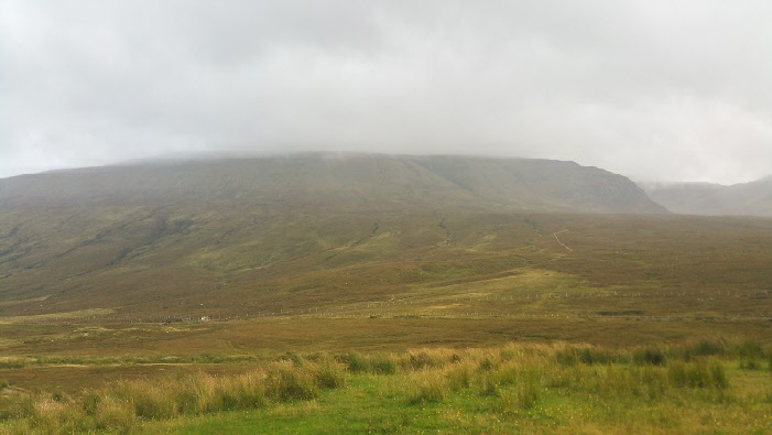
Moruisg from Glen Carron, summit just obscured by cloud.
Meaning - Big Water
Summit Location - NN10117, 49931
Height - 928m
Munro Number - 255
Distance - 11.5km (including Sgurr nan Ceannaichean)
Total Ascent - 992m
Time - 2.5hrs to Moruisg / 1hr to Sgurr nan Ceannaichean / 2hrs down
Difficulty - 2/5
OS Explorer Map - 429
Climbed - 2015
Weather - Rain at first, becoming drier. Cloud clearing the tops momentarily.
A relatively straight-forward walk which was just what I wanted to allow my legs
to recover after a long walk on the Five Sisters of Kintail the day before. This
route used to take in two Munros, but neighbouring Sgurr nan Ceannaichean was demoted
to Corbett status in 2009 - after re-measurement it was deemed to fall just below
the crucial 3000ft mark. The route described here includes the extension to Sgurr
nan Ceannaichean as it’s a pleasant enough walk, the the extra climb isn’t significant.
Parking is by the road in a lay-by just west of Loch Sgamhaim. You’ll cross the River
Carron on a bridge and go under the singe track Inverness - Kyle of Lochalsh railway
line. The path soon fizzles out and after crossing a deer fence you’re on to open
countryside.
It’s a tough slog up the rounded, grassy, north face of Moruisg. There aren’t really
any difficult sections, it just felt like a long climb. The summit lies just over
2km from the road.
It’d been raining since I left the car but as I ate lunch at the top the showers
ceased and through the breaks in the cloud I spotted Sgurr nan Ceannaichean. I decided
to walk on given the improving weather. Should you wish to climb Moruisg only I’d
recommend returning to the road by route of ascent, as descent via Coire Toll nam
Bian will add a lot of distance to the route.
Sgurr nan Ceannaichean is reached by descending south and then veering west to a
col. There’s then a short climb to the Corbett summit. It didn’t take very long and
was well worth it. Sgurr nan Ceannaichean is a much more compact, steep-sided peak,
in some ways feeling more like a ‘proper’ mountain than its Munro neighbour. Size
isn’t everything!
After admiring the views, particularly to the south and the remote Munros lying north
of Loch Monar, I returned to road via the north ridge, taking care to pass the various
crags with a short detour to the west and then descending in a north-easterly direction
into Coire Toll nam Bian, crossing the burn to pick up a stalkers path. This returns
you to the same railway underpass and and bridge over the stream you used during
the ascent. The path is very muddy and slippery in places - take care. Lower down
as you reach the glen is quite boggy. At least if you get wet feet you’re close to
the end of the walk!
Now it was off to the Torridon Inn for a burger and a pint to continue the recovery
process ready for some fun in Glen Torridon the next day...
Route
1 - Parking in the lay-by just west of Loch Sgamhaim, due south of the transmitter.
Take the footpath leading down to a bridge. Use this to cross the river then continue
on the path under the railway line.
2 - The path starts to climb the hillside. Cross the deer fence using the steps provided.
The path fades away at this point - continue more or less directly up the hill in
a south-south-easterly direction.
3 - Moruisg’s peak is rounded and stony. There are two cairns on the summit around
200m apart. The smaller cairn is the true summit! If intending only to climb the
Munro, return by route of ascent.
4 - If continuing to Sgurr nan Ceannaichean, descend along a path in a southerly
direction along a ridge, which narrows and veers west to a col. Continue up the
steeper ground to the west of the col to join Sgurr nan Ceannaichean’s north ridge.
It’s only a short climb to the summit, marked by a much smaller cairn than the one
on Moruisg. If the weather is favourable, take some time to admire the views of wilderness
to the south.
5 - To descend, return along the north ridge, but instead of bearing right to return
to the col, bear left to continue down the north ridge, passing crags on your right.
Watch out for a second line of crags further down the ridge (marked Creag a’ Chait
on OS Explorer maps). These are also passed by a short detour to the left.
6 - As the ridge opens out and all crags are behind you, bear north-east into Coire
Toll nam Bian, crossing the burn to pick up a stalkers path which follows the burn.
Continue on this muddy path, which bears right when you reach Glen Carron and leads
to the same railway underpass and and bridge you used earlier.