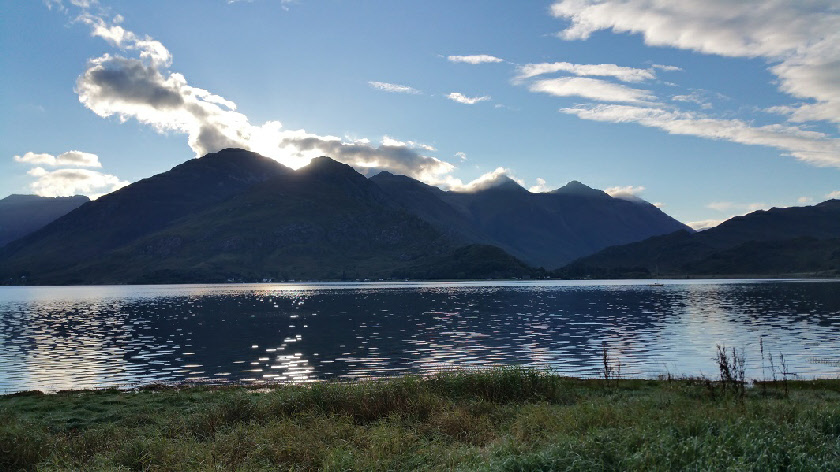
The Five Sisters from Ratagan
Sgurr Fhuaran
Meaning - Wolf Peak
Summit Location - NG97857, 16674
Height - 1067m
Munro Number - 70
Sgurr na Ciste Duibhe
Meaning - Peak of the Dark Chest
Summit Location - NG98406, 14950
Height - 1027m
Munro Number - 105
Sgurr na Carnach
Meaning - Rocky Peak
Summit Location - NG97718, 15877
Height - 1002m
Munro Number - 134
Distance - 12.1km (not including the walk back up the road, if a bus or car is not
used)
Total Ascent - 1541m
Estimated Time - 8hrs
Difficulty - 4/5
OS Explorer Map - 414
Climbed - 2015
Weather - Sunny, warm at first. With cloud coming later but above the summits. A
little cool in the wind on the ridge.
I'd already walked many of the peaks on either side of Glen Shiel and was keen to
add the Five Sisters to the list. After a night in the stunningly located Ratagan
youth hostel, I drove to the end of the ridge, at Allt a' Chruinn, and took the morning
Citylink bus up the glen to the start some eight kilometres away. The fare was a
whopping £7.00 - around about a pound a minute!
The path climbs quite steeply from the glen, to reach the Bealach an Lapain, the
lowest point on the ridge (at just above the 700m contour). It was very, very warm
going in the bright morning sun, though fortunately there was just enough of a breeze
to keep the midges at bay.
The ridge is fairly undulating and somewhat narrow between Sgurr nan Spainteach and
Sgurr na Ciste Duibhe. There's also a few simple scrambly manoeuvres. Once over Sgurr
na Ciste Duibhe the ridge widens as you approach the other two Munros. The climb
up to the last of these, Sgurr Fhuaran, is very steep.
After bagging the Munros I continued northwest, over Sgurr nan Saighaead and Beinn
Buidhe before descending to Allt a' Chruinn via Coire na Criche.
Remember that if you don’t use the bus or have a car at either end of the ridge,
you’ll need to walk the 11 kilometres back to the start to retrieve your vehicle.
This is on a busy road so be careful! Alternatively you may have some luck thumbing
a lift.
Route
1 - Start at the Five Sisters car park, which is located just under 2km east of the
site of the Glenshiel battle (marked on Ordnance Survey maps). A clear, and for a
short while well-constructed, path climbs the hillside between two plantations, beside
a burn. The path becomes muddier and less easy to follow. As you reach the top of
the plantation on your right the path turns right to follow the line of the fence
for a very short way, then turns uphill to climb an ill-defined ridge. The ridge
is a bit rockier than the ground covered so far whilst at least means you’re out
of the mud.
2 - Keep climbing the hillside until you reach the lowest point of the ridge, Bealach
an Lapain. Here, you turn left to ascend the ridge in a westerly direction. The ridge
is fairly narrow but there’s a clear path. You’ll pass the summits of Beinn Odhar
and Sgurr nan Spainteach (Peak of the Spaniards), named because this is where Spanish
troops spent the night during the 1719 battle of Glenshiel.
3 - After Sgurr nan Spainteach there’s then a steep, rocky descent on what is probably
the narrowest part of the ridge. After reaching the col, you should follow the path
to the right to climb a ridge. The path then veers left to climb steeply up to Sgurr
na Ciste Duibhe. The summit is marked by a cairn.
4 - To continue, head west along the path, following the crest of the now broader
ridge down to a rocky bealach. It’s not long until you’re climbing steeply again
towards your second Munro, Sgurr na Carnach. The peak is marked by another cairn.
5 - The path northwards drops very steeply to another bealach. You’ll probably need
to use your hands here but it’s not particularly difficult. After passing the bealach
the path continues steeply up the south ridge of your final Munro, Sgurr Fhuaran.
6 - That’s all the Munros completed, but you still have two of the five sisters to
climb. Don’t worry though - almost all the hard work is behind you. Follow the path
northwards, keeping well back from the sheer east cliffs, to Sgurr nan Saighead.
From this point, the path continues to Beinn Buidhe, with sheer cliffs continuing
on your right. The final climb up to Beinn Buidhe is quite steep but fortunately
short.
7 - After summiting Beinn Buidhe and savouring the views, descend northwards to another
bealach. The path is no longer as well defined so take care with your route finding,
particularly in poor weather - there’s a lot of steep ground around you. At the bealach
you have two options, continue ahead to the final sister Sgurr na Moraich and then
return to the same point or if time is running out head back down to Allt a' Chruinn.
8 - To descend, head down into the coire from the bealach. If you stick to the north
side of the burn you should pick up a faint, muddy, path. After a couple of kilometres
this becomes a stone path, which leads straight down to a small dam above the village
of Allt a' Chruinn. After the dam you can follow an gravel access road down to the
village.