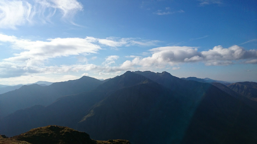
Bidean nam Bian is the tallest peak in the background. Stob Coire nan Lochan is in
front and centre of the shot, Stob Coire Sgreamhach is on the left.
Bidean nam Bian
Meaning - Chief of the Hills
Summit Location - NN14837, 54857
Height - 1150m
Munro Number - 23
Stob Coire Sgreamhach
Meaning - Peak of the Fearful Corrie
Summit Location - NN15493, 53654
Height - 1072m
Munro Number - 65
Distance - 10.6km
Total Ascent - 1375m
Estimated Time - 3.5hrs to Bidean nam Bian / 0.75hrs to Stob Coire Sgreamhach / 2hrs
down
Difficulty - 3/5
OS Explorer Map - 384
Climbed - 2014
Weather - Cloudy, with the base lowering just below the peaks halfway through the
walk. Dry.
I'd decided the time had come to do the Aonach Eagach in Glen Coe. What better way
to prepare by climbing some nearby peaks to get a better look at the ridge!
Bidean nam Bian is the highest Munro in Glen Coe. You can’t really see it from the
valley floor, the sheer north-facing buttresses of the Three Sisters are all you
can make out.
A good path climbs steeply from the glen, beside a burn to the west of Gearr Aonach.
At around the 750m contour you reach a corrie to the northeast of Stob Coire nan
Lochan, which you’ll need to climb by either the north or east ridge. I chose the
east ridge on the grounds that it negates the need to walk across the corrie floor,
and it’s a little more scrambly - a perfect warm-up for the Aonach Eagach, if a lot
simpler!
Once you’re on Stob Coire nan Lochan there’s a further descent, before you ascend
to Bidean nam Bian. The continuation to Stob Coire Sgreamhach is more of the same,
descend to a bealach and then some reascent to gain the Munro.
The Descent to the road is via the Lost Valley. This huge valley is almost invisible
from the road, as the entrance from the A82 side is very narrow. Legend has it that
cattle stole by the Macdonald clan were hidden here. There’s certainly space for
a lot of cows!
Route
1 - Start at the car park below Allt-na-reigh, which is located about 3km east of
the junction wth the road leading to the Clachaig Inn. A path drops down to a wooden
bridge which crosses the River Coe. A good path then climbs steeply into Coire nan
Lochan, to the east of a burn. Eventually the path fades and the corrie narrows.
Keep to the left of the burn and waterfalls and you’ll find a way up without too
much difficulty.
2 - You’ll emerge into the main corrie, with Stob Coire nan Lochan towering above
you. From here you can ascend the north ridge by crossing corrie floor and climbing
to your right or take the east ridge, which lies to your left. This route ascends
the latter.
3 - Gain the ridge to your left, by ascending pathless to the left of a line of crags.
Once on the ridge you’ll see a path. You can follow this or stick to the crest of
the ridge. Any scrambly manoeuvres are simple.
4 - After reaching Stob Coire nan Lochan’s peak you’ll need to follow the path southwards,
descending steeply to a bealach. The path then continues to the summit of Bidean
nam Bian. There’s probably some further easy scrambling to be found if you look for
it.
5 - To continue to Stob Coire Sgreamhach, descend to the southeast along a ridge.
After passing a small top you’ll descend to the Bealach Dearg. A short and straightforward
climb ahead will take you to your second Munro of the day.
6 - To descend via the Lost Valley, retrace your steps to the Bealach Dearg (Red
Col). From here a heavily eroded red muddy path descends steeply to the north, down
a little chute. This soon widens and a reasonable path descends to the west of the
Allt Coire Gabhail. The gradient eases the further you make your way down the valley,
which is around 2km long. The path disappears at one point as you cross a boulder
field.
7 - At the end of the valley you’ll reach an area with trees and some huge rocks.
The path can be a little hard to follow at this point. First it follows the east
side of the valley and then it splits. Take the left fork here. You’ll cross the
burn and descend, steeply again, through a wooden area and down to the Rover Coe.
Cross this using the footbridge, then continue the 500m or so back to the car park.
The path in the valley which parallels the A82 is a safer option than walking back
along the busy road.