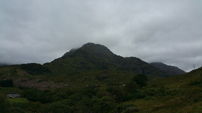
Most of Ben Vane is visible here, though the peak is obscured by cloud.
Meaning - Middle Mountain
Summit Location - NN27790, 09824
Height - 915m
Munro Number - 282
Distance - 11.5km
Total Ascent - 951m
Time - 2.5hrs up / 2hrs down
Difficulty - 4/5
OS Explorer Map - OL39
Climbed - 2015
Weather - Overcast but little if any wind. Peak just in the cloud.
Ben Vane is the joint smallest Munro (in height terms), though forms an impressive
steep-sided near pyramidal peak at the heart of the Arrochar Alps, a group of mountains
to the West of Loch Lomond. It’s separated from it’s neighbouring peaks by deep glens
so is probably best tackled on its own, unless you’re feeling particularly athletic!
Parking is at the visitor centre close to the Inveruglas hydro-electric power station.
An excellent track leading to the Loch Sloy dam allows easy access to the foot of
the mountain, then the simplest way is up the steep east ridge. There’s a few easy
scrambly moves on the final few metres of ascent, easy grade 1 scrambling. The adventurous
could probably find some tougher lines if desired.
Route
1 - Start at the car park at the visitor centre slightly to the north of Inveruglas
power station. Head south along the A82, passing the power station. You should use
the marked path on the west side of the road.
2 - After about 500m you will see a gate leading to a vehicle track which passes
under the railway. Take this track which climbs into the valley and then levels out.
Bear left at the first junction and then take the second track to the left. You should
immediately cross a bridge over a river.
3 - Follow the trail for about 400m as it climbs gently to the bottom of Ben Vane’s
southeast ridge. Once you reach this you’ll see a small path leading up the ridge,
to the left of a small crag. Ascend steeply for around 50m until you reach a small
plateau, which can be a little boggy.
4 - From this small plateau a large part of Ben Vane is visible in front of you.
Ascent the path, which is rather steep in places. As the slopes of the mountain get
steeper the path tend to wind it’s way to the north side of the ridge. It’s very
easy to follow and it’s walking rather than scrambling at this point.
5 - You’ll reach the first false summit at around 850m elevation. You’ll need to
continue along the path which leads to a line of crags. Some very simple scrambling
on lines to either the left or right is called for to ascend to a second false summit
at about 880m elevation.
6 - A little more scrambling up a few more rocks is required to reach the summit,
which is remarkably flat for such a steep sided mountain.
6 - Return by route of ascent. The initial scramble of the summit is straight forward,
the second section felt marginally easier by taking the lines on the left, but none
of the scrambling is particularly difficult.