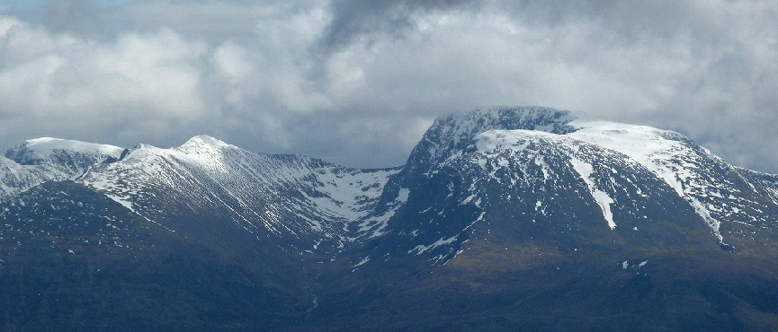
Carn Mor Dearg (centre left) and Ben Nevis (right). The arête is in the centre of
the shot. Photo credit: Flickr user Andrew.
Ben Nevis
Meaning - Venomous Mountain
Summit Location - NN16687, 71275
Height - 1343m
Munro Number - 1
Carn Mor Dearg
Meaning - Big Red Cairn
Summit Location - NN17753, 72161
Height - 1220m
Munro Number - 9
Distance - 16.7km
Total Ascent - 1628m
Time - 4.5hrs to Carn Mor Dearg / 1hr to Ben Nevis / 1.75hrs down
Difficulty - 4/5
OS Explorer Map - 392
Climbed - 2006
Weather - Day one: Dry but cloud. Day two: Overcast, becoming windy and wet.
This is the big one! Ben Nevis, the highest mountain in the UK can be busy and crowded
but it is all too easily forgotten that it is one of the finest Munros. I would well
recommended that everyone climbs it at least once, maybe even more than once as there
are many fine routes up the Ben.
The most common route is the Mountain Track from the visitors centre at Achintee.
This track, though steep in places is fairly easy going and suitable for the masses.
Many new walkers will take to this path in trainers if the weather is good, though,
as always, boots would be much more suitable. This route follows the Pony Track to
Lochan Meall an t-Suidhe and then zigzags straight up the east face of the Ben.
However, the aspiring Munro bagger may want to select a route that takes in the adjacent
peak, Carn Mor Dearg (CMD), as the route below does. It initially follows the Mountain
Track and then branches left at Lochan Meall an t-Suidheand, continuing round to
the North Face. As soon as you see this dramatic cliff wall you’ll begin to appreciate
the finer things this mountain has to offer, and also it's sheer size. You then climb
steeply up CMD’s east side, bag that peak and then continue over to the Ben via a
dramatic arête that links the two Munros. Not an easy route but the views and relative
quiet make it all the more enjoyable.
From the summit, the Mountain Track is a comparatively easy way down back to the
car park. Given my love of camping in high places I walked up to the Lochan in the
afternoon of day one, completing the rest of the route on the second day. This way
I already heading back down as I passed the crowds coming up. No photos from this
trip unfortunately, they seem to have disappeared over the years.
Warning - Whilst walkers with little experience can probably successfully navigate
the mountain track, this route is only suitable for those with scrambling experience.
the arête is a grade 1 scramble, and somewhat challenging in wet and windy conditions.
It is very exposed, with a drop of 200-300m either side (sheer in places).
Route
1 - Start at the visitor centre car park at Achintee. From here you need to follow
the Mountain Track for about 2.5km. The track is well built and though steep in places,
is generally easy going.
2 - As you reach the Lochan at about the 600m contour the track splits. Take the
left fork, to the north. You will then need to follow this track around the north
face. After another 2.5km. You will reach the private SMC-owned CIC hut.
3 - Take care when crossing the burn, particularly after heavy rain. There is no
more path, but you need to continue up the mountain face in front of you. It's not
quite a scramble, but very steep and you will probably find you use your hands in
places. There’s a fair bit of scree and it’s tough going.
4 - Aim to reach the ridge just to the north of the summit, then continue south for
the short distance to the summit of Carn Mor Dearg. Take care to avoid the sheer
drop on the east side of the mountain!
5 - From the peak you will see a worn path dropping down to the arête. Try to keep
to the crest of the ridge, it’s not overly difficult, much easier than the dramatic
pictures suggest in fine weather. There’s also a narrow but well-worn path, running
first on the north facing slope then after a short stretch on the crest it jumps
across to the south facing slope.
6 - The arête soon widens and from there it’s a very steep climb for the remaining
500m to the summit. Take care to stay well back from the sheer drop to your right.
7 - The summit of Ben Nevis is well marked with a trig. point, emergency shelter
and various ruins. Take care on the summit plateau in poor visibility or in the snow.
The summit is near to the North Face (a 600m sheer drop), and various gullies cut
into the plateau. You should read these instructions for bearings to find your way
down in bad weather (don’t guess, it’s easy to stumble into one of the gullies or
onto a cornice).
8 - To descend follow the well marked Mountain Track which will take you straight
back to the car park at Achintee.
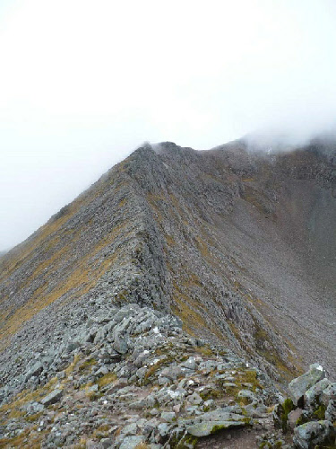
A closer view of the CMD arête. Photo credit: Flickr user Louise Scott.