© Copyright Dominic Rhodes 2014-2017

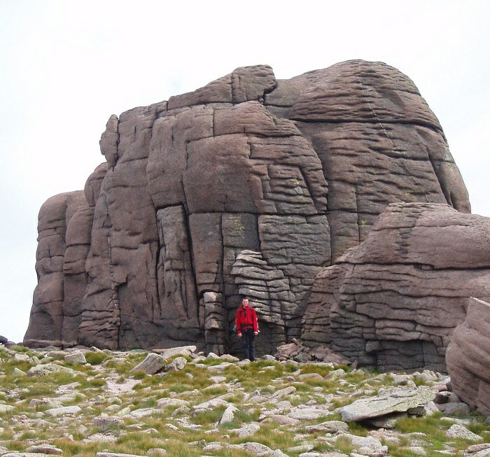
The granite tor that forms the summit of Beinn Mheadhoin.


Beinn Mheadhoin


Meaning - Middle Mountain

Summit Location - NJ02459, 01683

Height - 1182m

Munro Number - 13


Bynack More


Meaning - Big Chimney-pot, Big Cap

Summit Location - NJ04192, 06319

Height - 1090m

Munro Number - 54


Distance - 32km

Total Ascent - 1462m

Estimated Time - 10hrs + rest stops

Difficulty - 4/5

OS Explorer Map - OL57


Climbed - 2006

Weather - Overcast with sunny spells. Breezy.


Beinn Mheadhoin is deep in the Cairngorms. This is a very long route in remote terrain. If attempted in one day you’ll need to wait until the long summer days. A much better idea would be plan on spending a night, perhaps at the Fords of Avon Refuge, Hutchison Memorial Hut or a wild camp. This will give you the option to take in even more Cairngorm peaks. Don’t risk being benighted without a tent!


Beinn Mheadhoin is an interesting peak, crowned with a number of granite tors (you’ll need to scramble up the largest to reach the true summit, though the scrambling is straightforward). The views of the surrounding peaks are stunning. This isn’t called ‘Middle Mountain’ for nothing, you really are deep in the high Cairngorms.   


Bynack More also has a number of granite tors, the ‘Barns of Bynack’, though these sit slightly below and to the south of the summit, which itself is rather rocky in nature.


I used the route of descent described here to take in Bynack More on the way back from Beinn Mheadhoin. I’d wild-camped at Loch Etchachan following a climb of Ben Macdui the day before. This offered a view of the sun rising over Beinn Mheadhoin.


The temperature had dropped a little from the tropical conditions the day before and the wind had picked up.


The initial descent to Loch Avon is quite steep so the small beach at the foot of the loch provided a welcome opportunity to take a break. Ben Macdui looms large from here, as does Bynack More, the next port of call. Whilst plodding up the steep slope leading to Bynack More one of the clips that holds the laces on my boot broke. I was able to do a very basic repair job but would have to be careful as they were no longer giving decent ankle support to my ankle.


It was a long steady slog to reach the peak, and an even longer walk back to Glenmore Lodge. Over the two days I had walked over 40km. Celebratory beers and steak back in Aviemore went down rather well!


Route


1 - Start at the car park near the visitor centre and youth hostel. Follow the track that leads past Glenmore lodge. Go through the Ryvoan Pass, the track forks shortly after (around 3km from the car park). Take the right branch (the left leads to Ryvoan Bothy).


2 - Continue around 2km along this track until you get to a footbridge. Cross it. A footpath continues on the other side, where you’ll quickly arrive at a fork (NJ02200, 10438). Take the right fork onto a path which follows the River Nethy for around 7km, climbing to 807m to a col between Cairn Gorm and A’ Choinneach (The Saddle, NJ01827, 03313).   


3 - Two paths descend towards Loch Avon. Take the heading in an easterly direction to the eastern end of Loch Avon. Cross the River Avon and ascend the heathery northern slopes of Sron Ghorm and Beinn Mheadhoin. The climb is steep initially but the gradient eases as you near the summit.


4 - You’ll see a number of granite tors on Ben Mheadhoin’s summit plateau. The true summit is on the largest tor. A few simple scrambling moves will get you to the top (NJ02459, 01683).


    *If you’re planning to overnight at the Hutchison Memorial Hut you’ll want to head southwest from here,           first to Loch Etchachan and then down the path into Coire Etchachan.  


5 - Otherwise, retrace your steps to the foot of Loch Avon, taking care not to stray onto steeper ground either side of the route.


    *Assess your progress once you reach the loch. To continue on the route via Bynack More involves around         15.5km more walking, some of which does not follow paths, and a further 400m of ascent. If you’re

      making slower progress than expected you may want to retrace your steps to the Saddle and then back

       up Strath Nethy, a route that follows paths all the way. Those planning a night at the Fords of Avon

      refuge (1.5km from here) should follow the River Avon in an easterly direction.   


6 - To continue to Bynack Mor, from the foot of the loch head north-north-east up the rocky slopes of A’ Choinneach. The going is steep at first but eases as you climb. Pass over the minor summit of A’ Choinneach (NJ03225, 04866) which is marked with a cairn. Descend for a short while as you head north-north-east, then climb steeply to the rocky summit of Bynack Mor (NJ04192, 06319). As you climb, you’ll pass a number of granite tors to your right (the Little Barns of Bynack).


7 - After the obligatory summit pictures, descend in an easterly direction. Once you’ve descended 100m or so and are confident you have cleared the craggy terrain to your left, descend in a northerly direction, below and to the east of Bynack More’s rocky northern ridge. After around 1.5km you should meet a footpath above Coire Odhar (NJ04363, 07978).


8 - This footpath takes you north over boggy terrain between Bynack More and the minor peak of An Lurg. After around 1.5km you’ll start to descend towards the River Nethy and the footbridge you crossed at the beginning of the walk (in step two).


9 - Cross the footbridge and retrace your route through the Ryvoan Pass and past Glenmore Lodge. The car park is around 5km from the footbridge.  


The photos in this gallery include day one of the hike, the climb from Coire Cas to Ben Macdui and then an overnight camp at Loch Etchachan.


Beinn Mheadhoin, Bynack More

Ben Macdui, Ben Mheadhoin, Bynack More

Smartphone or iOS user? Click to see the images from my trip.

Search the page